
EXPERTISE YOU CAN TRUST
Our Vision: Subsurface Clarity.
Bluedrum Geo
At BlueDrum Geo, we go beyond the surface—combining cutting-edge technology with geological precision to deliver insights that others miss. Here’s what sets us apart:
- 3D imaging
- Subsurface resource quantification
- Depth estimation
- Rapid data processing
- Efficient field data acquisition
- Precision target marking
Explore the service
Void Detection
Explore the service
Shaft Mapping
Explore the service
Mineral Exploration
Explore the service
Underground Mapping
OUR IMPACT
The Power of Precise Subsurface Data.
At Bluedrum Geo, we move beyond basic detection. Our integrated approach uses advanced geophysical methods like GPR, LiDAR, Magnetometry, Gravity, and Resistivity to provide a complete, accurate understanding of your subsurface environment for confident project planning
123+
115+
- Advanced Technology for Unseen Discoveries.
- Experienced Team Delivering Reliable Results.
What we Provide
Our Best Services.
Precision GPR Surveys
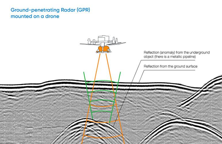
Utilizing high-frequency electromagnetic waves, our GPR systems precisely map utilities, rebar, geological features, and hidden voids with unparalleled accuracy and depth.
Drone Mapping & Sensing

Our advanced UAVs equipped with LiDAR and photogrammetry provide high-resolution terrain models, surface mapping, and volumetric calculations for vast or inaccessible areas.
Normal Magnetic & Gravity Testing

We detect subtle variations in the Earth's magnetic and gravitational fields to locate mineral deposits, geological structures, and buried objects at significant depths.
Void & Tunnel Mapping

Employing advanced GPR and integrated geophysical methods, we accurately pinpoint hidden cavities, old mine workings, and tunnels to ensure safety and secure development.
Targeted Mineral Exploration

Leveraging Magnetic, Gravity, and other techniques, we precisely identify and delineate potential mineral deposits, guiding efficient and profitable exploration efforts.
Site Characterization

Utilizing Drone Lidar or photogrammetry with GPR & other methods for unparalleled, detailed 2D/3D mapping of surface & buried features delivering robust data.
Our Commitment
Know More About Us
At Bluedrum Geo, we move beyond basic detection. Our integrated approach uses advanced geophysical methods like GPR, LiDAR, Magnetometry, Gravity, and Resistivity to provide a complete, accurate understanding of your subsurface environment for confident project planning.
We utilize GPR, LiDAR, Magnetometry, Gravity, and Resistivity with drone capabilities to deliver the most comprehensive and accurate data available.
We don't just find anomalies; we interpret their significance and provide strategic recommendations, turning data into clear pathways for your project's success.
Bluedrum Geo's multi-method strategy ensures a holistic view of the subsurface, providing deeper understanding where single methods fall short.
Our experts possess deep geological and geophysical knowledge, combined with practical field experience to tackle any subsurface challenge.
8
How it Works
Our Working Process
At Bluedrum Geo, we follow a streamlined and precise process to ensure every
project delivers optimal results and actionable insights. From initial consultation to br final data
delivery, our systematic approach guarantees efficiency and accuracy.


